21.12.200 OBAT Regulations Common to All Uses.
A. Regulations Common to All Uses.
|
Table 21.12.200A |
|||
|---|---|---|---|
|
Regulation |
Standard |
Exceptions |
|
|
Minimum |
|||
|
Front and Street |
10 feet |
A. Improvements less than 30 inches above grade, including decks, patios, walks and driveways, are permitted in setbacks. Fences, landscaping, flagpoles, street furniture, transit shelters and slope stability structures are permitted in setback areas, provided that all other applicable requirements are met. No other structures, including accessory structures, are permitted in setback areas. B. See Map 12.4, Overlake Business and Advanced Technology (OBAT) Setbacks, below for front and street setbacks along 148th Avenue NE. Setbacks shall be: 1. 20 feet for buildings 20 feet or less in height; or 2. 30 feet for buildings greater than 20 feet in height. C. See Map 12.4 below for Front and Street setbacks along Bel-Red Road. |
|
|
Rear |
20 feet |
||
|
Side |
30 feet |
||
|
Landscaping |
|||
|
Landscaping |
20 percent |
||
|
Maximum |
|||
|
Front and Street |
45 feet |
Applies in the locations noted on Map 12.4 below only. |
|
|
Impervious surface area, Height, and FAR |
|||
|
80 percent |
|||
|
Height |
Varies |
||
|
FAR |
Varies |
A. All legal lots are allowed the greater of either the maximum allowed FAR or 10,000 square feet of buildings provided all other applicable site requirements are met. B. The FAR for nonresidential and residential uses within a given development are individually calculated and may be added to together for a cumulative total, provided that the respective maximum FAR for each use is not exceeded, unless otherwise provided for. |
|
|
Drive-through |
n/a |
Drive-through facilities are prohibited except where expressly permitted in the Allowed Uses and Basic Development Standards table below. |
|
Map 12.4 |
|---|
|
Note: Online users may click the map for a full-size version in PDF format. |

B. Landscaping.
1. General Requirement. All setbacks, buffers, open spaces, pervious surfaces, plazas, parks, site and building entrances, pedestrian walkways, service areas, and parking lots shall be landscaped with plant materials. Existing vegetation may be maintained and apply toward this standard if the existing vegetation meets the landscaping requirements of this section, is healthy, and is likely to survive development. The requirements specified in RZC 21.32, Landscaping, shall apply except to the extent that they conflict with landscaping practices appropriate to an urban center. In addition, supplemental landscaping requirements are defined below.
2. Plantings Along Streets. At a minimum, planting strips along streets shall include street trees per the City’s standards for type and species. Where space allows, planting areas should include other vegetation suitable for an urban setting. Tree planting pits on streets that include furniture zones per RZC 21.12.200.C, Street Cross Sections, shall be covered with tree grates of a type that meets ADA requirements.
3. Buffers.
a. Landscape buffers at least 20 feet in width shall be provided in the locations shown on Map 12.5, Overlake Business and Advanced Technology (OBAT) Buffers.
b. The buffers shall be planted with the following materials:
i. Minimum of one tree per 200 square feet of buffer area. No more than 40 percent of trees may be deciduous.
ii. Evergreen shrubs, a minimum of five gallon in size. The area covered by the shrubs shall equal at least one-third of the buffer frontage.
iii. Groundcover plantings to cover the ground within three years.
iv. Plant materials shall be drought tolerant and at least 50 percent native species by area.
v. Trees and other plant materials required by this section shall be located so that they effectively buffer the development from bordering residential properties. The buffer need not completely obscure the development; rather it should screen it.
c. Up to 20 percent of the buffer area may be used for streets, driveways, utility crossings, trails, or ground level features such as patios. Other structures may not be placed in required buffers.
d. Buffers may be counted towards required open space, required pervious surfaces, setbacks, and other requirements in the Use and Bulk Regulations Table that the buffers meet.
4. Supplemental Buffer Requirements.
a. Purpose. The purpose of the supplemental buffer requirements is to protect nearby uses from the potential adverse impacts of more intense uses due to noise, glare, and the scale of development in locations where the lots are large enough for greater buffers than required by other provisions of the Redmond Zoning Code. Buffers shall be required in the locations set forth on Map 12.5, Overlake Business and Advanced Technology (OBAT) Buffers.
Map 12.5 |
|---|
|
Note: Online users may click the map for a full-size version in PDF format. |

b. The width of all required buffers shall be measured at right angles to the property line. Regardless of right-of-way expansions in the future due to purchases, dedications, the granting of easements, or any other means, the buffer shall be measured from the property line as it existed on July 1, 2010.
c. Notwithstanding any other provision of this title, the 100-foot greenbelt along the portion of Bellevue-Redmond Road identified above in Map 12.5, Overlake Business and Advanced Technology (OBAT) Buffers, shall be planted and maintained so that it blocks vision from the unaided human eye through the greenbelt along both sides of Bellevue-Redmond Road from ground level to a height of 55 feet above the ground surface. This greenbelt shall consist of an evergreen canopy, a middle story of deciduous and evergreen trees, and an understory of shrubs, plants, and smaller trees. While the plants shall be primarily of types native to the area, soils and microclimate, nonnative ornamental plants may also be included.
d. Existing significant trees within the buffers and open space shall be retained when possible. Berms within the buffer and open space areas should be planted with a mixture of medium-scale evergreen trees and shrubs to provide additional visual buffering to nearby properties.
e. The greenbelts and buffers provided for in this section shall comply with the applicable requirements of RZC 21.32, Landscaping, and RZC 21.72, Tree Preservation, except as specifically provided by this section.
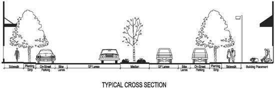
C. Street Cross Sections.
1. Guidelines for Application.
a. The Technical Committee shall review and approve each component of the street cross section on a project-by-project basis and has the authority to alter street cross section widths and uses, including utility locations.
b. Street cross section widths apply at the middle of the block.
i. The widths and existence of each component may vary at intersections, as determined by the Technical Committee.
ii. Intersection design shall be based upon the Pedestrian System Plan, Bicycle System Plan, and Design Guidance chapters of the Transportation Master Plan; the Bicycle Facilities Design Manual; the City’s Construction Specifications and Design Standards for Streets and Access; and any corridor study adopted by the City Council for the street(s) in question.
c. Provisions of medians and left-turn lane access shall be determined on a project-by-project basis, based on traffic speeds, volumes and collision history, and using recognized engineering standards, such as those published by AASHTO, ITE, or other recognized authority.
d. Utilities, such as power, telephone and cable, shall be placed under the sidewalk.
e. When designing multimodal corridors refer to the Modal Corridors section of TMP. Corridors shall support all modes.
2. Map 12.6, Overlake Business and Advanced Technology (OBAT) Cross Sections and Table.
Map 12.6 |
|---|
|
Note: Online users may click the map for a full-size version in PDF format. |

|
Figure 21.12.200 |
|---|
|
|
Table 21.12.200B |
||||||||
|---|---|---|---|---|---|---|---|---|
|
Standard |
Cross Section |
|||||||
A |
C |
D |
F |
G |
H |
I |
J |
|
|
Right of Way Geometry |
||||||||
Sidewalk |
8 (SB/WB); |
6 (Both Sides) |
12 (Both Sides) |
6 (Both Sides) |
8.5 (Both Sides) |
8 (SB/WB); |
8.5 (SB/WB); |
8.5 (Both Sides) |
Five-Foot Planting Strip or Four-Foot Furniture Zone with Tree Grates |
5 (Both Sides) |
5 (Both Sides) |
4 (Both Sides) |
5 (Both Sides) |
0 (Both Sides) |
0 (Both Sides) |
0 (SB/WB); |
0 (Both Sides) |
On-Street Parking |
0 (Both Sides) |
0 (Both Sides) |
8 (Both Sides) |
0 (Both Sides) |
0 (Both Sides) |
0 (Both Sides) |
0 (Both Sides) |
0 (Both Sides) |
Bike Lane |
0 (Both Sides) |
5.5 (Both Sides) |
5.5 (Both Sides) |
5.5 (Both Sides) |
5.5 (Both Sides) |
5.5 (Both Sides) |
5.5 (Both Sides) |
5.5 (Both Sides) |
GP Lanes |
22 (Both Sides) |
11 (Both Sides) |
11 (Both Sides) |
22 (Both Sides) |
22 (Both Sides) |
22 (Both Sides) |
22 (Both Sides) |
11 (Both Sides) |
Median / Two-Way Left Turn Lane |
12 |
12 |
14 |
12 |
12 |
14 |
12 |
12 |
|
Notes |
||||||||
|
Notes |
A. Separate multiuse path parallel to corridor. B. Street section shared by Bellevue and Redmond. C. Outside GP lane 13 feet. Inside GP lane 11 feet. |
A. Interim pending the results of a corridor study conducted in coordination with identification of a light rail alignment by the Sound Transit Board of Directors. B. Light rail in the corridor would result in the removal of the median and on-street parking. |
Street trees shall be planted in sidewalk area as otherwise required by the Parks Department’s Street Tree Program. |
A. Street trees shall be planted in sidewalk area as required by the Parks Department’s Street Tree Program. B. Expanded pedestrian zone shall include ten-foot-wide sidewalk between two planting areas, one adjacent to the street and one adjacent to adjacent private development. Total right-of-way width shall be 82 feet, with easement for remainder of expanded pedestrian zone. |
Street trees shall be planted in sidewalk area as required by the Parks Department’s Street Tree Program. |
|||