S Definitions.
Salmon and Steelhead Habitat. Submerged areas that provide significant habitat or critical habitat components for salmon and steelhead at various life cycle stages, including gravel-bottomed streams and rivers used for spawning; streams, rivers, lakes, wetlands and side channels used for rearing or feeding, and refuge from predators and high waters; and shallow areas along lakeshores used for rearing, feeding, and refuge. Salmon and steelhead habitat is mapped on the Stream Map in the Shoreline Master Program. (SMP)
Effective on: 4/16/2011
Salmonid. A species of the family Salmonidae: the salmons, trouts, chars, and whitefishes. (SMP)
Effective on: 4/16/2011
Satellite Dish Antenna(s). A type of antenna(s) and supporting structure consisting of a solid, open mesh, or bar configured reflective surface used to receive and/or transmit radio frequency communication signals. Such an apparatus is typically in the shape of a shallow dish or cone.
Effective on: 4/16/2011
Secondary Containment. Containment designed to hold an unauthorized release external to a primary container.
Effective on: 4/16/2011
Secondary Room. See Primary Room, Secondary Room.
Effective on: 4/16/2011
Secure Community Transition Facility. A residential facility for persons civilly committed and conditionally released to a less restrictive alternative under RCW Chapter 71.09. A secure community transition facility has supervision and security, and either provides or ensures the provision of sex offender treatment services. Secure community transition facilities include, but are not limited to, the facilities established pursuant to RCW 71.09.250 and any community-based facilities established under RCW Chapter 71.09, and operated by or under contract with the Washington State Department of Social and Health Services.
Effective on: 4/16/2011
Security Lighting. Lighting designed and used to discourage crime and undesirable activity.
Effective on: 4/16/2011
Security Lighting, Basic. A lighting level allowed for most developments in order to provide a reasonable level of illumination for the security of persons or property.
Effective on: 4/16/2011
Security Lighting, Enhanced. A lighting level reserved for areas where personal security is an issue, such as where an area is open to the public during all hours of the night, where special security needs exist, or where vandalism or crime is likely without the increased level of illumination.
Effective on: 4/16/2011
Sediment. Material that originates from weathering and erosion of rocks or unconsolidated deposits, and is transported by, suspended in, or deposited by water.
Effective on: 4/16/2011
Sedimentation. The deposit or accumulation of sediment.
Effective on: 4/16/2011
Seismic Hazard Areas. Lands or areas subject to severe risk of damage as a result of earthquake-induced ground shaking, slope failure, settlement, or soil liquefaction.
Effective on: 4/16/2011
Sending Areas. Properties designated to transfer their development rights.
Effective on: 4/16/2011
SEPA Rules. WAC Chapter 197-11 adopted by the Department of Ecology.
Effective on: 4/16/2011
Service Area. Any area devoted to garbage or refuse containers, incinerators, the shipping or receiving of commodities, or the parking of trucks or other large vehicles used in the operation of an enterprise.
Effective on: 4/16/2011
Service Vehicle. A vehicle engaged in loading or unloading operations such as pick-up and drop-off for patients or passengers, or bulk pickups and deliveries for commodities, merchandise, equipment or household items. A typical service vehicle includes but is not limited to emergency aid car, carpool van, delivery truck or moving truck with a similar size as a single-unit truck (SU-30). (Ord. 3028)
Effective on: 2/27/2021
Services to Buildings or Dwellings. The provision of services, such as extermination and pest control, janitorial services, landscaping maintenance, and carpet and upholstery cleaning. This definition does not include packing, crating, and convention and trade show services, which are separately defined and regulated. This definition does include vending machine operators.
Effective on: 4/16/2011
Setback. The distance between a property line and the corresponding parallel setback line.
Effective on: 4/16/2011
Setback Line. A line beyond which, toward a property line, no structure greater than 30 inches above finished grade may extend or be placed except as permitted by the regulations of this title.
Effective on: 4/16/2011
Setback Zone. The setback zone is shown in RZC 21.12.150, OV (Overlake) Street Cross Sections. It is located outside of the right-of-way, ensures that objects do not encroach on useable sidewalk space, and helps to maintain sight lines at driveways. In the Overlake Village Zones, it provides space for hardscape improvements or container plants. In the OBAT Zone, it provides space for plantings. It is also described in Redmond’s Transportation Master Plan - Pedestrian System Plan. (Ord. 2803)
Effective on: 10/17/2015
Sexually Oriented Materials. Any books, magazines, periodicals or other printed materials, or any photographs, films, motion pictures, video cassettes, slides, or other visual representations, that are distinguished or characterized by a predominant emphasis on matters depicting, describing, or simulating any specified sexual activities or any specified anatomical areas. The term “sexually oriented materials” includes any instruments, devices, or paraphernalia designed for use in connection with any specified sexual activities.
Effective on: 4/16/2011
Shall. Means a mandate; the action must be taken. (SMP)
Effective on: 4/16/2011
Shared Street. A slow-speed street shared by pedestrians, cyclists, and vehicles. (Ord. 2978)
Effective on: 11/30/2019
Shop or Store Building with Drive-Through Facility. A retail commercial building with a drive-through window to serve customers in motor vehicles.
Effective on: 4/16/2011
Shorelands or Shoreland Areas. Those lands extending landward for 200 feet in all directions as measured on a horizontal plane from the ordinary high water mark; floodways and contiguous floodplain areas landward 200 feet from such floodways; and all wetlands and river deltas associated with the streams, lakes, and tidal waters which are subject to the provisions of the Shoreline Management Act; the same to be designated as to location by the Department of Ecology. That portion of a 100-year floodplain may be included as long as such portion includes, as a minimum, the floodway and adjacent land extending landward 200 feet there from. (SMP)
Effective on: 4/16/2011
Shoreline Modification. Those actions that modify the physical configuration or qualities of the shoreline area, usually through the construction of a physical element, such as a dike, breakwater, pier, dredged basin, fill, bulkhead, or other shoreline structure. They can include other actions, such as clearing, grading, or application of chemicals. (SMP)
Effective on: 4/16/2011
Shoreline Stabilization. Means for protecting shoreline upland areas and shoreline uses from the effects of shoreline wave action, flooding or erosion. Shoreline stabilization includes structural and nonstructural methods, riprap, bulkheads, gabions, jetties, dikes and levees, flood control weirs, and bioengineered walls or embankments. (SMP)
Effective on: 4/16/2011
Shorelines. All of the water areas of the state, including reservoirs, and their associated shorelands, together with the lands underlying them; except:
2. Shorelines on segments of streams upstream of a point where the mean annual flow is 20 cubic feet per second or less and the wetlands associated with such upstream segments; and
3. Shorelines on lakes less than 20 acres in size and wetlands associated with such small lakes. (SMP)
Effective on: 4/16/2011
Shorelines of Statewide Significance. Those lakes, whether natural, artificial, or a combination thereof, with a surface acreage of 1,000 acres or more measured at the ordinary high water mark, and those natural rivers or segments thereof where the mean annual flow is measured at 1,000 cubic feet per second or more. Definition is limited to freshwater areas in Western Washington. (SMP)
Effective on: 4/16/2011
Short Plat. The map or representation of a short subdivision.
Effective on: 4/16/2011
Short Subdivision. The division or redivision of land into nine or fewer lots, tracts, parcels, sites, or divisions for the purpose of sale, lease, or transfer of ownership.
Effective on: 4/16/2011
Should. Means that the particular action is required unless there is a demonstrated, compelling reason, based on policy of the Shoreline Management Act and the Shoreline Rules, against taking the action. (SMP)
Effective on: 4/16/2011
Side Street Setback. The side setback that is applied to that side of a lot which has a side yard facing a private or public street or access corridor. (Ord. 2803)
Effective on: 10/17/2015
Sign. A communication device, structure, or fixture which incorporates graphics, symbols, or written copy that is intended to promote the sale of a product, commodity or service, or provide direction or identification for a premises or facility.
Effective on: 4/16/2011
Sign Area. The total area of a single face of a sign, including the framing structure surrounding the face, measured as follows:
1. Freestanding and Projecting Signs. If the sign is composed of three or less individual sign cabinets, the area of the sign shall be the combined area of all cabinets measured by the smallest square or rectangle that will enclose each cabinet. If the sign has more than three sign cabinets or modules, the area shall be the smallest single continuous square or rectangle that will enclose the entire perimeter of all cabinets or modules.
2. Wall Signs. The sign area shall be the area contained within the smallest square or rectangle that will enclose the entire advertising message or decoration or the entire sign cabinet, provided that if the advertising message is composed of individual letters that use the wall as background with no added decoration, the total sign area shall be the combined area of the smallest squares and rectangles that will enclose each letter.
Effective on: 4/16/2011
Sign, Directional. A permanent sign not exceeding six square feet in area, without commercial message, that guides pedestrian or vehicular traffic with directional messages, such as “one way,” or “exit only”; guides the public to specific on-site locations, such as an entrance, exit, parking, or service area, or to a particular aspect of a business or establishment such as a cocktail entrance; or that contains noncommercial information or directions provided by a public agency, such as safety warnings or user rules and regulations. (SMP)
Effective on: 4/16/2011
Sign Height. The vertical distance from the grade below the sign to the uppermost module, cabinet, or character.
Effective on: 4/16/2011
Sign, Informational. A sign not exceeding six square feet in area commonly associated with, but not limited to, information and directions necessary or convenient for visitors coming on the property, including signs marking entrances and exits, parking areas, circulation direction, rest rooms, and pickup and delivery areas. (SMP)
Effective on: 4/16/2011
Sign, Interpretive. A permanent sign not exceeding six square feet in area, without commercial message, located on a publicly accessible site, that provides public educational and interpretive information related to the site on which the sign is located, such as information on natural processes, habitat restoration programs, or cultural history, or that is associated with an adopt-a-stream, adopt-a-park, or similar agency-sponsored program. (SMP)
Effective on: 4/16/2011
Significance/Significant - Cultural Resources. Consistent with the National Historic Preservation Act, the quality of significance in history, architecture, archaeology, engineering, and culture present in a district, site, building, structure, or object that possesses integrity of location, design, setting, materials, workmanship, feeling, and association, and a) that is associated with events that have made a significant contribution to the broad patterns of history; or b) that is associated with the lives of significant persons in the past; or c) that embodies the distinctive characteristics of a type, period, or method of construction, or that represents the work of a master, or that possesses high artistic values, or that represents a significant and distinguishable entity whose components may lack individual distinction; or that has yielded or may be likely to yield information important in history or prehistory. (Ord. 2982)
Effective on: 1/2/2020
Significant Ecological Impact. An effect or consequence of a human-caused action if any of the following apply:
1. The action degrades or changes an ecological function or ecosystem-wide process to such a degree that the ecosystem can no longer perform the function at levels within its natural range of variability or that the performance of the function falls outside the range needed to maintain the integrity of other ecological processes in shoreline areas.
2. Scientific evidence or objective analysis indicates that the action could cause degradation or change to those ecological functions or ecosystem-wide processes described above under foreseeable conditions.
3. Scientific evidence indicates that the action could contribute to degradation or change to ecological functions or ecosystem-wide processes described above as part of cumulative impacts, due to similar actions that are occurring or likely to occur. (SMP)
Effective on: 4/16/2011
Significant Feature. Any architectural detail, distinctive stylistic feature of a historic landmark structure, or distinctive feature of a historic landmark site that is identified on the designation report as contributing to its designation as a historic landmark. In the case where a designation report was not prepared in advance of designation, the Administrator determines what features are significant based on review by experts in historic preservation.
Effective on: 4/16/2011
Significant Groundwater Hazard. A condition in which there is a reasonable probability of release of a hazardous material or deleterious substance that, if reached groundwater, would degrade, alter or form part of a process of degradation or alteration of the groundwater quality so that it becomes or is likely to become harmful for consumption. (Ord. 2957)
Effective on: 4/27/2019
Significant Tree. Any healthy tree six inches in diameter at breast height (d.b.h.), or any tree four inches in diameter at breast height (d.b.h.) that, after considering its age, height, value, or function, the tree or tree stand is determined to be significant. (SMP). This term also applies Citywide.
Effective on: 4/16/2011
Single-Room Occupancy Units (SROs). A structure containing single-room living units with small cooking units (independent or common) and other amenities not ordinarily associated with a hotel.
Effective on: 10/17/2015
Site. Any lot or parcel or any combination of contiguous lots or parcels on which a single, integrated development is proposed.
Effective on: 4/16/2011
Site - Cultural Resources. Location of a significant event, a prehistoric or historic occupation or activity, or a building or structure, whether standing, ruined, or vanished, where the location itself possesses historic, cultural, or archaeological value regardless of the value of any existing structure. (Ord. 2982)
Effective on: 1/2/2020
Six-Year Program. A term of reference that includes the Transportation Improvement Program (TIP) and the Capital Investment Program (CIP). The TIP and CIP are the six-year funded list of transportation improvements, including facilities, programs, projects, and services adopted by the City, which serves to implement the adopted Transportation Facilities Plan (TFP) and thus maintain the City’s adopted transportation Level of Service (LOS) standard.
Effective on: 4/16/2011
Size-Limited Dwelling. A single-family detached unit that does not exceed 1,900 square feet. The determination of total square footage includes attached and detached garages. A size-limited dwelling will be so identified and legally binding on the title of the home; enlarging the home will not be permitted above the maximum size limit. (Ord. 2709)
Effective on: 10/26/2013
Slope. A degree of deviation of a surface from the horizontal, measured as a numerical ratio, percentage, or in degrees. Expressed as a ratio, the first number is the horizontal distance (run) and the second is the vertical distance (rise), as 2:1. Expressed as a percentage, the vertical distance (rise) is divided by the horizontal distance (run) and is then multiplied by 100. A 2:1 slope is a 50 percent slope. Expressed in degrees, the slope is the angle from the horizontal plane, with a 90-degree slope being vertical and 45 degrees being a 1:1, or 100 percent slope.
Effective on: 4/16/2011
Small Lot Short Plat. The short subdivision of a lot that is not required to meet the minimum average lot size for the underlying zone and subject to the criteria in RZC 21.08.170.E.2. (Ord. 2709)
Effective on: 10/26/2013
Small Satellite Dish. Any satellite dish antenna(s) that has a diameter less than or equal to one meter located in Urban Recreation, Semirural, Residential zones or Shoreline areas of the City or two meters within any other zone. [See Satellite Dish Antenna(s).]
Effective on: 4/16/2011
Small Wireless Facilities or small cell(s). Are facilities that meet each of the following conditions:
A. The facilities-
1. are mounted on structures 50 feet or less in height including their antennas, or
2. are mounted on structures no more than 10 percent taller than other adjacent structures, or
3. do not extend existing structures on which they are located to a height of more than 50 feet or by more than 10 percent, whichever is greater;
B. Each antenna associated with the deployment, excluding associated antenna equipment, is no more than three cubic feet in volume;
C. All other wireless equipment associated with the structure, including the wireless equipment associated with the antenna and any pre-existing associated equipment on the structure, is no more than 28 cubic feet in volume;
D. The facilities do not result in human expore to radiofrequency radiation in excess of the applicable safety standards specified in 47 CFR § 1.1307(b). (Ord. 2964)
Effective on: 4/27/2019
Special Design Areas. Special Design Areas are public rights-of-way, including streets, in the
following locations:
1. Cleveland Street between Redmond Way and 164th Avenue NE
2. Leary Way between NE 80th Street and West Lake Sammamish Parkway NE
3. Gilman Street between the Redmond Central Connector and NE 80th Street
4. Bear Creek Parkway and 170th Avenue NE from Redmond Way to Redmond Way in Downtown Redmond
5. 152nd Avenue NE between NE 20th and NE 31st streets in the Overlake Neighborhood
Full concealment of all wireless communication facilities within the Special Design Areas is required, including within poles, street furniture, garbage cans, mailboxes and other similar features. In limited circumstances, the City can allow wireless communication facilities in Special Design Areas under the following conditions:
1. They are camouflaged,
2. They are designed, integrated into, and consistent with the design theme of a pole, and
3. That there is no alternate location outside of the Special Design Area that can provide similar service. (Ord. 2919)
Effective on: 4/14/2018
Snag. An upright stump or trunk of a tree that provides habitat for a broad range of wildlife, from beetle larvae (and the birds such as woodpeckers that feed upon them) to dens for raccoons. (SMP)
Effective on: 4/16/2011
Social Assistance, Welfare, and Charitable Services. The provision of social assistance services, including shelters, directly to individuals in need. (Ord. 2709)
Effective on: 10/26/2013
Soften. To mitigate, diminish, or reduce impacts. When used in connection with softening the transition between existing and new dwellings, soften means to reduce the impacts to the existing dwelling(s) as a result of a change from the previous conditions to the new residential development.
Effective on: 4/16/2011
Soil. The natural or processed, unconsolidated mineral and organic material on the immediate surface of the earth that does or is suitable to serve as a natural medium for the growth of land plants.
Effective on: 4/16/2011
Solar Access. The amount of unrestricted sunlight that reaches a structure, or portion thereof. (Ord. 3083)
Effective on: 7/2/2022
Solid Waste. All putrescible and non-putrescible solid and semisolid wastes as defined in WAC Chapter 173-304, Minimum Functional Standards for Solid Waste Handling.
Effective on: 4/16/2011
Solid Waste. Unwanted or discarded material, including waste material with insufficient liquid content to be free flowing. (SMP)
Effective on: 4/16/2011
Solid Waste Transfer and Recycling. The collection, treatment, sorting, or disposal of residential or commercial solid waste or recycling materials at a central facility. (Ord. 2652)
Effective on: 4/28/2012
Sound Level. See RMC Chapter 6.36, Noise Standards.
Effective on: 4/16/2011
Sound Level Meter. See RMC Chapter 6.36, Noise Standards.
Effective on: 4/16/2011
Species of Concern. Those species listed as state endangered, state threatened, state sensitive, or state candidate, as well as species listed or proposed for listing by the U.S. Fish and Wildlife Service or the National Marine Fisheries Service.
Effective on: 4/16/2011
Species of Local Importance. Species identified by the City of Redmond, including those that possess unusual or unique habitat warranting protection because of qualitative species diversity or habitat system health indicators. It may also include species which are culturally important to the City. Species of local importance are designated through the development guide amendment process.
Effective on: 4/16/2011
Specified Anatomical Areas. Any of the following:
1. The human male genitals in a discernibly turgid state, even if completely and opaquely covered; or
2. Less than completely and opaquely covered human genitals, pubic region, anus, buttocks, or female breast below the top of the areola.
Effective on: 4/16/2011
Specified Sexual Activities. Any of the following:
1. The caressing, fondling, or other erotic touching of human genitals, pubic region, buttocks, anus, or female breasts; or
2. Sex acts, normal or perverted, actual or simulated, including intercourse, oral copulation, or sodomy; or
3. Masturbation, actual or simulated; or
4. Excretory functions as part of, or in connection with, any of the sexual activities specified in this definition.
Effective on: 4/16/2011
Sports Team or Club Venue. An arena, field, or stadium for a professional or semiprofessional sports team or club that participates in live sporting events, such as baseball, football, hockey, or soccer.
Effective on: 4/16/2011
Stacked Flat. A type of residential structure characterized by attached dwelling units that have upper and lower units. (Ord. 3083)
Effective on: 7/2/2022
State Environmental Policy Act (SEPA). Contained in RCW Chapter 43.21C, this Washington state law is intended to minimize environmental damage. SEPA requires that state agencies and local governments consider environmental factors when making decisions on activities, such as development proposals over a certain size and comprehensive plans. As part of this process, environmental checklists are prepared to disclose impacts and propose mitigation. This process also provides an opportunity for public comment.
Effective on: 4/16/2011
Stealth Technology. Technology that camouflages, conceals, or otherwise makes the antenna array, antenna support structure, base station, and feed lines not readily identifiable as such, and which is designed to be aesthetically similar to existing and proposed buildings, vegetation, and uses on a site. Examples of stealth technology include, but are not limited to, painting antennas, antenna support structures, feed lines, and base stations to match the color of an existing building or structure or the color of the sky or vegetation, providing a background for the facility, concealing the antenna support structure, feed lines, and base station through the use of faux windows, dormers or other architectural features that blend with an existing building or structure, or concealing antenna support structures, feeder lines, and base stations within another structure that has a secondary function, such as a church steeple, windmill, bell tower, clock tower, cupola, light standard, utility pole, flagpole, or tree.
Effective on: 4/16/2011
Steep Slopes. Slopes of 40 percent gradient or steeper.
Effective on: 4/16/2011
Storage, Shipping, or Moving Container. A reusable container that was originally constructed or was originally manufactured to be used for transport, moving and storage. These units are typically constructed or assembled of, but not limited to, canvas, corrugated and weathering steel, or aluminum, and come in varying lengths and heights. They are transported by container ships, trucks, or trains. This definition is not intended to include garbage and/or recycling containers.
Effective on: 4/16/2011
Stormwater Facilities. Constructed or natural systems that are designed to provide stormwater management.
Effective on: 4/16/2011
Stormwater Management. The collecting, conveyance, channeling, holding, retaining, detaining, infiltrating, diverting, treating, or filtering of surface water, ground water, and/or runoff together with applicable managerial (nonstructural) measures.
Effective on: 4/16/2011
Stormwater Technical Notebook. Describes the requirements for new development and redevelopment projects within the City of Redmond. Land developers and development engineers use the Notebook to help design site plans and determine stormwater infrastructure. (Ord. 2858)
Effective on: 12/17/2016
Story. That portion of a building included between the upper surface of any floor and the upper surface of the floor next above, except that the topmost story shall be that portion of a building included between the upper surface of the topmost floor and the ceiling or roof above. If the finished floor level directly above a usable or unused underfloor space is more than six feet above grade as defined herein for more than 50 percent of the total perimeter or is more than 12 feet above grade as defined herein at any point, such usable or unused underfloor space shall be considered a story. For non-buildings, or for other instances where measurement in stories is insufficient, a story shall equal 12 feet.
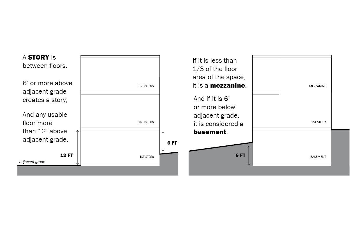
(Ord. 2652; Ord. 2958)
Effective on: 4/27/2019
Strategy. An approach or method that, when used for transportation purposes, incorporates the use of transportation facilities, projects, programs and services to provide mobility for people and goods, and thus maintain the City’s adopted transportation Level-of-Service (LOS) standard.
Effective on: 4/16/2011
Stream. Those areas where surface waters produce a defined channel or bed. A defined channel or bed is an area which demonstrates clear evidence of the passage of water and includes, but is not limited to, bedrock, channels, gravel beds, sand and silt beds, and defined-channel swales. The channel or bed need not contain water year-round. This definition is not meant to include artificially created irrigation ditches, canals, storm, or surface water runoff devices or other entirely artificial watercourses unless they are used by salmonid or created for the purposes of stream mitigation.
Effective on: 4/16/2011
Stream Reconnaissance Report. A report prepared by an applicant’s qualified consultant to describe a stream and to characterize its conditions, wildlife, habitat values, and water quality.
Effective on: 4/16/2011
Street. Any thoroughfare which affords the principal means of access to abutting properties, access corridors, or driveways, which has been dedicated or deeded to the public for public use.
Effective on: 4/16/2011
Streetscape. The visual elements of a street, including the roadway, sidewalks, adjoining buildings, street furniture, trees, and open spaces that combine to form the street’s character.
Effective on: 4/16/2011
Street Frontage. The length along a public or private right-of-way upon which a structure, business, or lot directly abuts.
Effective on: 4/16/2011
Structural Diversity. The relative degree of diversity or complexity of vegetation in a wildlife habitat area as indicated by the stratification or layering of different plant communities (e.g., ground cover, shrub layer and tree canopy), the variety of plant species, and the spacing or pattern of vegetation.
Effective on: 4/16/2011
Structure. That which is constructed and placed permanently on or under the ground or over the water, or attached to something having a permanent location on or under the ground or over the water, excluding residential fences less than six feet in height; retaining walls, rockeries, patios, and decks less than 30 inches in height; and similar improvements of a minor character. For the purpose of administering the Shoreline Master Program, structure shall have the meaning given in WAC 173-27-030(15). For the purposes of administering the Wireless Communication Facilities code, structure shall have the meaning given in under 47 CFR 1.6002. (Ord. 2652; Ord. 2964)
Effective on: 4/27/2019
Structure Mounted Facility. A structure or building that can accommodate a Wireless Communication Facility that is mounted on the top/roof or side/facade of the structure or building. The term does not encompass a tower or antenna support structure, or any equipment associated with a tower or antenna support structure, or a utility pole, light pole, traffic signal pole or miscellaneous pole. (Ord. 2919; Ord. 2964)
Effective on: 4/27/2019
Structure, Detached. A structure which has no common or party wall with another structure.
Effective on: 4/16/2011
Subdivision. The division or redivision of land into 10 or more lots, tracts, parcels, sites, or divisions for the purpose of sale, lease, or transfer of ownership.
Effective on: 4/16/2011
Substantial Change. A modification substantially changes the physical dimensions of an eligible support structure if it meets any of the following criteria:
1. For towers other than towers in the public rights-of-way, it increases the height of the tower by more than 10% or by the height of one additional antenna array with separation from the nearest existing antenna not to exceed twenty feet, whichever is greater; for other eligible support structures, it increases the height of the structure by more than 10% or more than ten feet, whichever is greater;
2. For towers other than towers in the public rights-of-way, it involves adding an appurtenance to the body of the tower that would protrude from the edge of the tower more than twenty feet, or more than the width of the Tower structure at the level of the appurtenance, whichever is greater; for other eligible support structures, it involves adding an appurtenance to the body of the structure that would protrude from the edge of the
structure by more than six feet;
3. For any eligible support structure, it involves installation of more than the standard number of new equipment cabinets for the technology involved, but not to exceed four cabinets; or, for towers in the public rights-of-way and base stations, it involves installation of any new equipment cabinets on the ground if there are no pre-existing ground cabinets associated with the structure, or else involves installation of ground cabinets that are more than 10% larger in height or overall volume than any other ground cabinets associated with the structure;
4. It entails any excavation or deployment outside the current site;
5. It would defeat the concealment elements of the eligible support structure; or
6. It does not comply with conditions associated with the siting approval of the construction or modification of the eligible support structure or base station equipment, provided however that this limitation does not apply to any modification that is non-compliant only in a manner that would not exceed the thresholds identified above. (Ord. 2919)
Effective on: 4/14/2018
Substantial Improvement. Any repair, reconstruction, or improvement of a structure, the cost of which equals or exceeds 50 percent of the market value of the structure either (1) before the improvement or repair is started, or (2) if damaged, the value of the structure to be restored prior to being damaged.
Effective on: 4/16/2011
Substitute Material. Any material that replaces the original material. If replacement is necessitated by the deterioration of the original, any material made of a different substance than the original material or any material that does not match the original material in its appearance.
Effective on: 4/16/2011
Substrate. The soil, sediment, decomposing organic matter, or combination of those materials located on the bottom surface of the wetland.
Effective on: 4/16/2011
Subterranean Parking. Parking that exists, occurs, or is situated below the ground surface. Also, referred to as below-grade parking or underground parking. Semi-subterranean parking is when less than one-half of the parking level (one parking "floor") is situated below the ground surface. (Ord. 2803)
Effective on: 10/17/2015
Supergraphic. An artistic graphic wall design theme.
Effective on: 4/16/2011
Supplemental Mitigation. Mitigation required by the City which is necessary for a proposed development to meet concurrency requirements of RZC 21.52, Transportation Standards. “Supplemental mitigation” shall mean unfunded facilities, programs, projects and services that are in the City’s Transportation Facilities Plan (TFP) or Unfunded Build-out Transportation Facilities Plan (UBTFP). (Ord. 2803)
Effective on: 10/17/2015
Survey - Archaeology, Cultural Resources. The physical search for and recording of cultural resources on or in the ground. The process may be limited to background research and presentation of existing data or include field survey(s), presentation of data from the field survey(s), development of inventories, and preparation of recommendations for National Register of Historic Places eligibility, effects, and mitigation. (Ord. 2982)
Effective on: 1/2/2020
Surveyor. A person licensed by the State of Washington to engage in the practice of land surveying, as defined by RCW 18.43.020.
Effective on: 4/16/2011
Sustainability. Meeting the needs of the present without compromising the ability of future generations to meet their own needs.
Effective on: 4/16/2011
Sustained Yield. A level of harvest of a renewable resource per year (or other time period) that can be continued without jeopardizing the ability of the ecosystem to be fully renewed, and thus to continue to provide an undiminished level of harvest each year long into the future. (SMP)
Effective on: 4/16/2011
System Improvements, Transportation. For purposes of administering RZC 21.52, Transportation Standards, system improvements are those facilities, programs, projects, and services that are included in the Transportation Facilities Plan (TFP), are designed to maintain mobility, and meet the Transportation Level-of-Service (LOS) Standard established in Redmond Comprehensive Plan Transportation Policy TR-4. Costs for these facilities, programs, projects, and services may include funding for Transportation Demand Management (TDM), transportation planning, preliminary engineering, engineering design studies, land surveys, right-of-way acquisition, engineering, permitting, and construction of all the necessary features for any transportation construction project. System improvements include, but are not limited to:
A.
1. Construction of new travel lanes, paths, sidewalks, trails, and terminal facilities for a variety of travel modes, including motor vehicles, bicycles, pedestrians, transit, and high occupancy vehicles;
2. Construction of new bridges;
3. Construction of new drainage and utility facilities as a result of new travel lanes, streets, paths, sidewalks, and trail construction;
4. Purchase and installation of traffic signalization (including new and upgraded signalization, signal interconnection, and supporting hardware and software) necessary to serve a variety of travel modes using travel lanes, paths, sidewalks, and trails;
5. Construction of curbs, medians, shoulders, and sidewalks;
6. Relocating, including undergrounding, utilities to accommodate construction of new travel lanes, streets, paths, sidewalks, and trails;
7. Other strategies, including programs and services such as TDM that reduce the demand to travel by motor vehicles;
8. Provision of transit service. (Ord. 2803)
Effective on: 10/17/2015
System Protective of Groundwater. A system at a facility that serves to protect groundwater quality, including but not limited to stormwater systems, wheel wash systems, and secondary containment systems associated with hazardous materials.
Effective on: 4/16/2011