21.14.070 Bear Creek Design District.
A. Purpose. The purpose of the Bear Creek Design District (comprising Performance Area 1 and Performance Area 2) is to provide development potential on the upland portion of the Bear Creek Design District in the northwest portion of the site in a comprehensive master plan that would allow for the permanent protection of Bear Creek, its riparian corridor, and associated wetlands and floodplains. The Design District provides for the location of retirement residence facilities, associated limited support services, and affordable housing for employees. The Design District will provide critical links in the Bear and Evans Creek Greenway System, an important planned regional trail along Bear and Evans Creeks. The balance of the undevelopable portion of this district will be established as a wetland mitigation banking site.
The following table is specific to this zone and provides references for each of the major topics that are regulated throughout the code. The individual topics provide function as connection or linkage to the chapters and sections of the Redmond Zoning Code that apply to development within this zone.
Land and Structure
|
| Environment
| Community
| Process
| Money
| Incentives
| Other
| |
|---|---|---|---|---|---|---|---|---|


B. Maximum Development Yield.
|
Table 21.14.070A |
||||
|---|---|---|---|---|
|
Base |
Residential Bonuses Available, and Quantity |
Maximum |
Illustration |
|
|
Floor area ratio (FAR) |
0.80 |
None |
0.80 |
Example of a 4-story building with FAR = 0.80 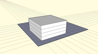
|
|
Height |
4 stories |
None |
4 stories |
|
C. Regulations Common to All Uses.
1. Maximum height of structures or portions of structures located above parking shall not include the distance between the finished grade of the parking surface and the structure, or the stories of the structure devoted to parking.
2. Maximum height in shoreline areas is 30 feet.
3. Impervious surface area resulting directly from the Bear and Evans Creek Trail and Greenway is exempt from impervious surface area calculations.
4. Drive-through facilities are prohibited except where expressly permitted in the Allowed Uses and Basic Development Standards tables below.
D. General Allowed Uses and Cross-References. The following tables provide references for each of the allowed use classes for the zone. References are provided for assistance in associating the current use classes with the use classes and associated definitions that were in effect prior to December 31, 2021. Additional references assist in generally aligning use classes with the Redmond Building Code, Institute of Transportation Engineers (ITE) Trip Generation Manual, and the City’s business licensing system. Additional information specific to the intended use may be necessary.
Uses that are not listed below nor within the associated definition of the individual use category or class shall be classified by the Code Administrator for applicability based on the purpose and intent of the zone within which the use is proposed.
Residential Use Category | Residential Use Class | Former Use Classification (Prior to Dec. 31, 2021) | Use Permissions Performance Area 1 | Use Permissions Performance Area 2 | Building Code Occupancy Class | ITE Trip Generation Manual Land Use Code |
|---|---|---|---|---|---|---|
L | N | I | 200 – 299 | |||
L | N | R | 200 – 299 | |||
L | N | R | 200 – 299 | |||
P | N | I | 200 – 299 |
Nonresidential Use Class | Former Use Classification (Prior to Dec. 31, 2021) | Use Permissions | Building Code Occupancy Class | ITE Trip Generation Manual Land Use Code | Nonresidential Use Class |
|---|---|---|---|---|---|
L | N | B | 700 – 799 | ||
P | N | ||||
C | N | ||||
P | N | ||||
P | P | ||||
Ambulatory or outpatient care services; nursing, supervision, and other rehabilitative services; social assistance, welfare, and charitable services | L | N | I | 600 – 699 | |
1. Limited to ambulatory or outpatient care services; nursing, supervision, and other rehabilitative services; and social assistance, welfare, and charitable services. | |||||
L | N | E | 500 – 599 | ||
L | L | ||||
P | P | ||||
Wireless communication facilities | Wireless communication facilities | N | P |
E. Allowed Uses and Basic Development Standards. The following tables contain the basic zoning regulations that apply to uses in the Bear Creek Design District (BCDD) zone. To use the chart, read down the left-hand column titled “Use.” When you have located the use that interests you, read across to find regulations that apply to that use. Uses are permitted unless otherwise specified in the Special Regulations column. Permitted uses may require land use permit approval. See RZC 21.76.020, Overview of the Development Process, for more information for more information.
|
Table 21.14.070B |
|||||||
|---|---|---|---|---|---|---|---|
|
§ |
Use |
Minimum |
Maximums |
Parking Ratio: |
Special Regulations |
||
|
Setbacks (ft) for 1- and 2-Story, 3-Story, and 4-Story Structures, Respectively |
Height (Stories) |
FAR |
|||||
|
Residential1 |
|||||||
|
1 |
Avondale: 15, 75, 150 |
30%; |
4 |
0.80 |
Dwelling unit (1.0, 1.0) |
A. Ten percent of the total number of dwelling units (including those built for employees) shall be affordable to individuals or families earning up to 80 percent of area median income. Applicant is allowed to apportion affordable units to buildings as applicant sees fit. B. Applicant is entitled to number of TDRs equal to number of affordable units provided. C. A traffic mitigation plan is required. The plan shall address traffic control, parking management (including mitigation of overflow parking into adjoining residential areas), and traffic movement to the arterial street system. |
|
|
2 |
Studio (1.2, 1.2) 1 bedroom (1.5, 1.5) 2 bedrooms (1.8, 1.8) 3+ bedrooms (2.0, 2.0) |
A. Permitted only to house employees and the families of housing services for the elderly. B. Ten percent of the total number of dwelling units (including those built as housing services for the elderly) shall be affordable to individuals or families earning up to 80 percent of area median income. Applicant is allowed to apportion affordable units to buildings as applicant sees fit. C. Applicant is entitled to number of TDRs equal to number of affordable units provided. D. See RZC Chapter 21.20, Affordable Housing, for additional guidance. |
|||||
|
3 |
|||||||
|
4 |
Dwelling unit (2.0) |
||||||
|
5 |
Avondale: 15, 75, 150 |
30%; |
4 |
0.80 |
Permitted only as internal service to residents and guests of housing services for the elderly. |
||
|
Transportation, Communication, Information, and Utilities |
|||||||
|
6 |
Avondale: 15, 75, 150 |
30%; |
4 |
0.80 |
Adequate to accommodate peak use |
See RZC Chapter 21.56, Wireless Communication Facilities, for specific development requirements. |
|
|
7 |
A conditional use permit may be required; see RZC Chapter 21.56, Wireless Communication Facilities, for specific development requirements. |
||||||
|
8 |
A. RZC Chapter 21.56, Wireless Communication Facilities. B. Conditional use permit required. See RZC 21.76.070.K, Conditional Use Permit. |
||||||
|
Arts, Entertainment, and Recreation |
|||||||
|
9 |
Avondale: 15, 75, 150 |
30%; |
4 |
0.80 |
1,000 sq. ft. gfa (0, adequate to accommodate peak use) |
||
|
Education, Public Administration, Health Care, and Other Institutions |
|||||||
|
10 |
Avondale: 15, 75, 150 |
30%; |
4 |
0.80 |
Permitted only as internal service to residents and guests of housing services for the elderly. |
||
|
11 |
A. Permitted only as internal housing services for the elderly. B. Curriculum must be related to geriatrics/gerontology. |
||||||
|
Agriculture, Forestry, Fishing, and Hunting |
|||||||
|
12 |
Avondale: 15, 75, 150 |
0; |
0 |
0 |
|||
Notes:
1Permanent supportive housing, as defined under RCW 36.70A.030, and transitional housing, as defined under RCW Chapter 84.36, are allowed in all land use districts where residential dwellings and/or hotel uses are allowed, subject to RZC 21.57.010, Permanent Supportive Housing, Transitional Housing, and Emergency Housing.
|
Table 21.14.070C |
||||
|---|---|---|---|---|
|
§ |
Use |
Maximums |
Special Regulations |
|
|
FAR |
||||
|
Arts, Entertainment, and Recreation |
||||
|
1 |
0; |
0 |
||
|
Agriculture, Forestry, Fishing, and Hunting |
||||
|
2 |
0; |
0 |
||
|
Transportation, Communication, Information and Utilities |
||||
|
3 |
Wireless communication facilities |
See RZC Chapter 21.56, Wireless Communication Facilities, for specific development requirements. |
||
F. Site and Design Requirements.
1. Where conflicts between this chapter and other chapters of the Redmond Zoning Code exist, the provision of this chapter shall control.
2. Development in this zone shall substantially conform to the conceptual site plan submitted as an exhibit to Ordinance 2370 adopting this chapter.
3. As a condition of site plan entitlement, the applicant shall convey to the City the following easements:
a. Conservation easements for all BCDD land outside PA-1 not already conveyed or purchased for other purposes, such as the wetland mitigation bank and trail easements.
b. Easements through the southern and eastern portions of the site, as depicted on the Bear and Evans Creek Confluence-Open Space Plan, to allow the City of Redmond to connect City trails.
4. Buildings shall be designed to achieve LEED, BuiltGreen, or other similar green building specifications. Certification shall include third-party auditing.
5. Site design shall incorporate low-impact development technologies to the extent feasible and practicable, including but not limited to, infiltration of nonpollution-generating stormwater and use of pervious paths.
6. The piped and culverted subterranean watercourse that flows southwest from the northwest corner of the site shall be rerouted.
a. For the portion of the watercourse that is within PA-1, the rerouting and daylighting shall occur in the following manner:
i. The watercourse riparian corridor shall contain plantings that reinforce the bank structure and provide shade;
ii. The design of the riparian corridor shall, to the extent possible within the limited space, mimic naturally occurring riparian corridors with respect to native vegetation, shading, and the provision of meander spaces;
iii. The corridor shall not contain impervious surfaces, but may be bridged for up to four vehicle crossings and two pedestrian crossings; those crossings shall conform to Washington State Department of Fish and Wildlife standards for culvert crossings allowing fish passage;
iv. Crossings shall minimize adverse impacts to the stream corridor;
v. The average width of the corridor shall measure no less than 15 feet; in no case shall the corridor measure less than ten feet across.
b. The portion of the watercourse that is within PA-2 shall be treated as a Class II stream, and the project proponent shall enhance the channel, banks, and required buffers from its entrance into PA-2 to the confluence with Bear Creek. This enhancement shall include, at a minimum, planting of native trees, shrubs and herbaceous species and incorporation of large woody debris (e.g., snags, root wads, and downed logs) for enhancement of fish and wildlife habitat.
7. Landscaping and Vegetation Preservation.
a. In addition to landscaping standards described in RZC 21.32, Landscaping, and RZC 21.72.060, Tree Protection Standards, the following standards shall apply:
b. All pervious surfaces shall be landscaped, except those areas to be preserved in or restored to natural conditions, areas such as pervious pathways, and areas within PA-1 in the 100-year FEMA floodplain.
c. Up to 20 percent of the required landscape area may be met by providing pedestrian plazas for gathering.
G. Cross-references. For information on how to measure various site requirements like height and setbacks, see RZC 21.16.020, How to Measure Site Requirements. See RZC 21.16.030, Other Applicable Regulations, for information on other standards that may apply to you. (Ord. 2652; Ord. 2803; Ord. 2919; Ord. 3074; Ord. 3083)